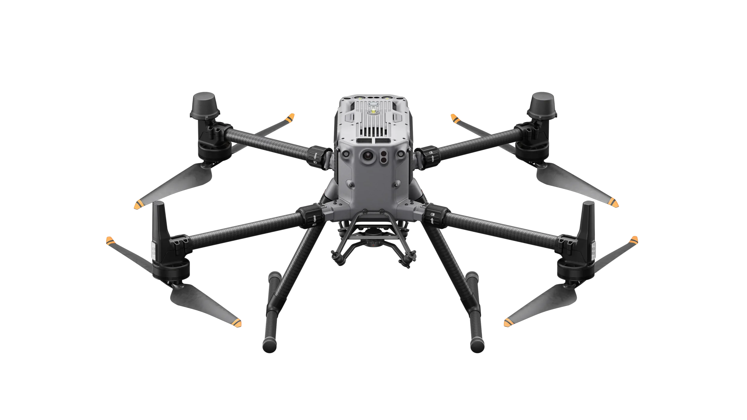
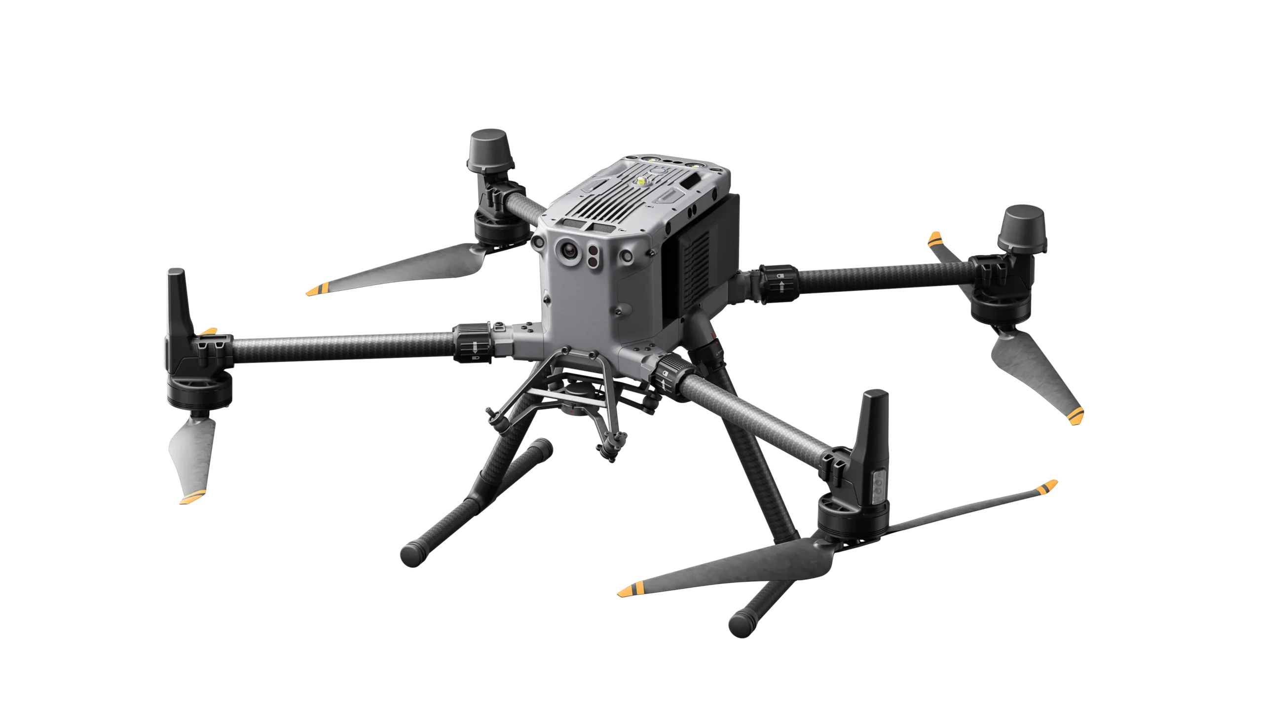
Description
Effortlessly Powerful Flight Performance
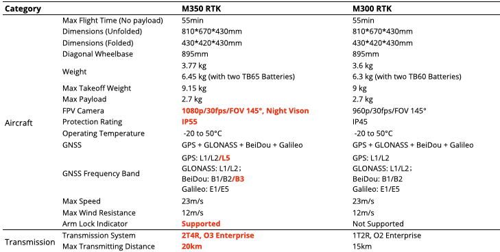
- 55 min max flight time
- IP55 protecting rating
- Night-Vision FPV Camera
- 2.7kg Max payload
Stay Stable With New Transmission System
- O3 Enterprise Transmission
- Triple 1080p Live Feeds
- 20 km max transmission range
- 4 Antenna design
New Control Experience
- 7-inch high-brightness screen
- IP 54 rating, -20 to 50℃
- DJI Pilot 2
Upgraded Battery System
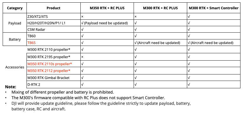
- TB65 Battery
- 400 charge cycles
- Next-Gen battery station
Built in Tough
Weatherproof for operation in various environments
- IP55 rating for the aircraft.
- IP54 rating for the RC plus
- 12m/s wind resistance
- -20°C to 50°C | -4°F to 122°F operating range
- 7000m Max Flight Altitude
Enhanced Flight safety
Arm Lock Indicator
- New arm lock detection function to avoid the risk of unlocked arm sleeves
Nigh-Vision FPV Camera
6-Directional Sensing & Positioning
CSM Radar
Multi-Layered Redundancy Design
Enhanced Flight safety
Arm Lock Indicator
Nigh-Vision FPV Camera
- The night-vison FPV camera can clearly present the surroundings and obstacles during flight at night.
6-Directional Sensing & Positioning
CSM Radar
Multi-Layered Redundancy Design
Enhanced Flight safety
Arm Lock Indicator
Nigh-Vision FPV Camera
6-Directional Sensing & Positioning
- 6-directional binocular vison and infrared sensing system, providing comprehensive protection during flight
CSM Radar
Multi-Layered Redundancy Design
Enhanced Flight safety
Arm Lock Indicator
Nigh-Vision FPV Camera
6-Directional Sensing & Positioning
CSM Radar
- With the CSM Radar, M350 can detect subtle obstacles upward or within the horizontal 360° range and avoid them in time.
Multi-Layered Redundancy Design
Enhanced Flight safety
Arm Lock Indicator
Nigh-Vision FPV Camera
6-Directional Sensing & Positioning
CSM Radar
Multi-Layered Redundancy Design
- Both the aircraft system and the sensor system of the Matrice 350 RTK adopt a redundant design to ensure flight safety, allowing you to cope with harsh operating environments more confidently.
Stay Stable With New Transmission System
O3 Enterprise Transmission
- 20 km | ~12.43 miles transmission range
- Improved anti-interference algorithm
- Triple Channel 1080p HD live feed
- Supports 5.2GHz (Only available in CE region)
Four-Antenna Design
- Two additional antenna on the back of aircraft
- 2 Transmitting, 4 Receiving (The system will intelligently select the two optimal antennas to transmit signals, while the four antennas receive signals simultaneously)
- 2x media download speed
Powerful GNSS & RTK module
New GNSS Chip
- M350 RTK equips new GNSS chip which has better signal reception and can get more satellites.
New RTK Module
- The new RTK module supports GPS L5 band. After turning on RTK, the RTK would be fixed faster and easier.
Upgraded Battery System
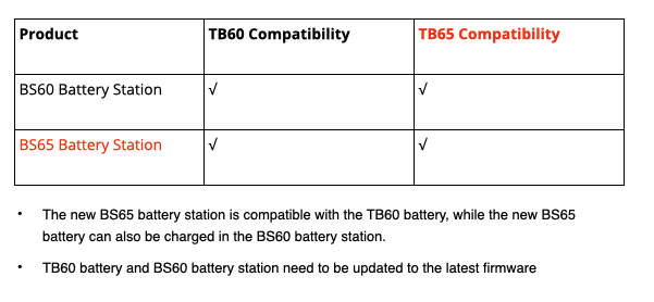
TB65 Intelligent Flight Battery
- 400 charge cycles
- Self-heating in low temperature
- Self-discharge for storage
- Charge without waiting for cooling*
*The Ambient temperature should be below 37℃. When the Ambient temperature is 50℃, will need to wait around 15mins for cooling
BS65 Battery Station
- 8 x TB65 Battery Ports, 4 x WB37 Battery Ports, 1x USB-C Maintenance Port, 1 x USB-C Charging Port and 1 x USB-A Charging Port
- Charges two aircraft batteries, one RC battery (WB37), and one RC Plus at the same time
- Intelligent Management: When the station is connected to RC Plus, it will display the battery health information
Upgraded Battery System
Multiple Charging Mode
Standard Mode
- Each pair is charged to 100% in sequence (will self- discharge)
- 60 min from 0 to 100%
-
Recommend for general user
Ready-To-Fly Mode
- Each pair is charged to 90% in sequence and kept at 90%
- 30 min from 20 to 90%
-
Recommend for first responders
Storage Mode
- Each pair is charged and kept at 50%
-
Recommend for long-term storage
Optimized Aircraft and battery cases
M350 Carrying Case
- Universal wheel, easier to move
- Dual payload slot, can carry two payload at the same time
- 800 x 359 x 543 mm, 31% reduced compared with M300 carrying case
BS65 Battery Station
- 580 mm×358 mm × 254 mm, 8.98 kg
- Universal wheel, easier to move
- Can carry 8 x TB65 and 4 x WB37 for transportation
Powerful Payloads
With a max payload capacity of 2.7 kg, the aircraft can carry up to three gimbal brackets and four payloads
Supported Gimbal
- Single downward gimbal, dual downward gimbals, and single upward gimbal
E-Port Open Interface
- E-Port is a new generation of open interface on DJI Enterprise drones, and the pin definition is consistent with the OSDK interface.
- E-port can realize the functions of both OSDK and PSDK interface
DJI Payloads
Meeting the needs of different operation scenarios like public safety, inspection, and mapping.
Hybrid Sensor – H20 Series
-
The four-sensor system of zoom camera, wide camera, thermal camera, and laser rangefinder.
Starlight – H20N
-
Starlight zoom and wide-angle cameras, dual zoom thermal cameras and a laser rangefinder.
Full-Frame Surveying Camera – P1
-
Full-frame sensor with interchangeable fixed-focus lenses on a 3-axis stabilized gimbal. Designed for photogrammetry flight missions.
Lidar – L1
-
Livox Lidar module, a high-accuracy IMU, and a mapping camera, efficiently capturing the details of complex structures and delivering highly accurate reconstructed models.
*Existing payloads need be updated to the latest firmware to adapt M350 RTK.
Third party payloads
- Spotlight
- Multispectral sensor
- Megaphone
- 5-lens camera
- Laser methane telemeter
- Spectrum analyzer
- Gas detector
- 50mm thermal imaging sensor
- 4-in-one UV sensor
Existing 3rd party payloads for M300 need to be updated to support the M350, and some need be upgraded the Skyport from V1 to V2, please consult the payload vendors for details.
Accessories
DJI RC Plus
- 7 inch screen, 1200 cd/m² brightness
- IP54 rating, -20 to 50℃
- 8-core chip, 4x CPU and 7x GPU power compared to Controller Enterprise
- Battery Life: 6 hrs with WB37
CSM Radar
- Detection Angle: Horizontal 360°, Vertical 60°, Upward 45°
- Detection Range: 1.5 to 30 m
- Max Speed with Obstacle Avoidance: 10 m/s
- Accurately detect subtle obstacles
Low Noise & High Altitude Propeller
- Improve flight performance in high altitude environment
- The noise of the propellers is reduced by 2 dB compared to the 2110s propellers
Professional Software
DJI Pilot 2
- The RC has built-in DJI Pilot 2 APP
- Supports multiple mission planning options, including waypoint, mapping, oblique, linear.
DJI FlightHub 2
- Flight Hub 2 features are also available including live streaming, aircraft info, live 2D mapping, panorama and media upload, and mission planning.
DJI Terra
- All-in-one Platform: 2D/3D, multispectral, Lidar point cloud reconstruction.
- Various types of deliverables to satisfy multiple business needs.
DJI Thermal Analysis tool 3.0
- DJI Thermal Analysis Tool 3 is supported at launch allowing you to create a report and manipulate the radiometric thermal data with the specific parameters following data capture.
Extensibility
Payload SDK
- Provides three integration ways, E-Port, SkyPort V2 and DJI X-Port, greatly reducing the development cycle of payloads
Mobile SDK
- Easily deploy custom apps for your fleet of DJI drones using mobile devices, enabling managers to optimize flights across their operations
Cloud API
- No more App development. Synchronize the drone with your cloud platform directly through DJI Pilot2
User Data Security & Compliance
- Media Data Encryption
- Local Data mode
- One-Tap Clear All Device Data
- AES-256 Video Transmission Encryption
- Private Deployment (Cloud API)
- C3 Marking* (For EU Region)
* The C2 marking for Mavic 3 Enterprise Series and M30 Series will also be finished within this year.
High-precision Mapping
Multiple Mission Flight
- Matrice 350 RTK supports Waypoint, Mapping, Oblique, and Linear Flight missions; Supports Terrain Follow or Smart Oblique for efficient data collection
High-Precision
- RTK positioning, TimeSync feature, ensuring high accuracy without GCP.
- Together with DJI Terra, you can quickly obtain HD 2D and 3D digital results, enabling high-precision and high-efficiency mapping operation.
Air-To-Ground Coordination
Information Synchronization
- With functions like the high-precision PinPoint and cloud-based real-time mapping, the Matrice 350 RTK can link the air, ground, and cloud together.
- After the aircraft completes image collection, DJI FlightHub 2 can quickly model the operation site and transmit command information to the aircraft and ground operators.
Automated Precision Inspection
Automated Inspection
- Through Live Mission Recording, it can generate and store flight route files that can be used at any time to realize automated operation.
- When using AI Spot-Check, it supports automatic framing and manual adjustment of subjects to improve the accuracy of repeated shooting and the quality of inspection operation.
